The Ultimate Guide to Bukit Larut (Maxwell Hill): the Resort Hill Station in Taiping, Perak
If you visit Taiping, after having taken your time to sample the amazing Taiping food, please look beyond the town and the beautiful Taiping Lake Gardens, and ponder at the beautiful hill that chisels the horizon with its endless viridian strokes. That is Bukit Larut, also known as Maxwell Hill, a former British Hill Station and resort created in the 1880s by the assistant resident of Perak, William Edward Maxwell. It’s Malaysia’s second hill station after Penang Hill, which was developed in 1788.
Bukit Larut overlooks Taiping’s beautiful Lake Gardens and the old town. Together with other Perak attractions like Ipoh’s Cave temples (check some Ipoh Airbnb we selected for you), serene Pangkor Island, the mangroves of Kuala Sepetang, the river village of Kuala Kurau and the migratory bird reserve at Kuala Gula, and the UNESCO World Heritage site of the Lenggong Valley, Bukit Larut is a must-visit.
Malaysia is a tropical country, but the top of Bukit Larut looks like you have traded sun and humidity for a slice of cold and foggy Britain: charming cottages dot perfectly landscaped gardens, clouds and mist come and go, bringing scattered rains, and the temperature can drop down to 10–12 degrees Celsius at night. Bring some warm clothing if you decide to overnight here.
Bukit Larut is perfect for outdoor lovers and hikers, who can strike up to the summit.
This article will describe:
- Where to Stay in Taiping before or after your visit
- How to Hike to the Top of Bukit Larut
- What to do in Bukit Larut
Where to Stay in Taiping before or after your visit
If you plan on hiking Bukit Larut all the way to the summit, you must stay in Taiping for the night to start walking early enough. Taiping has a very good selection of hotels (click here for our ultimate list of Taiping Best Hotels) and these are some of our favorites:
-
Novotel. You can’t go wrong with this popular brand, central and practical.
-
Raintown Homestay it’s a perfect apartment for groups or families and fits up to 8 people.
- The Cozytainer has swanky beds in shipping containers, the first of its kind in Taiping. Book on Booking.com
-
Sojourn Beds & Cafe is Taiping’s first hostel, straight in the old town.
-
Louis Hotel is central and surprisingly cheap for the swanky and comfy rooms it offers.
Where is Bukit Larut’s entrance?
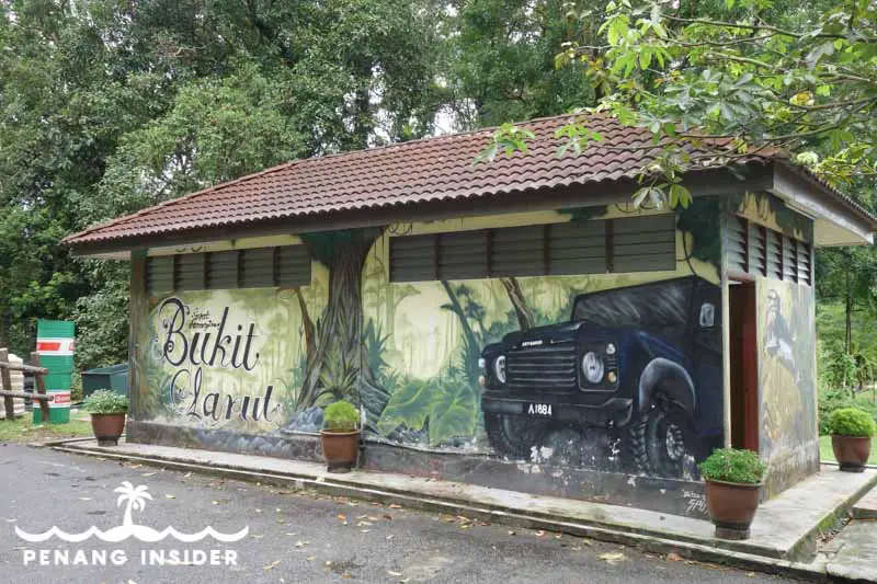
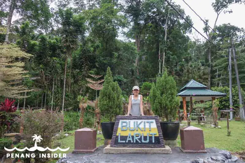
You can access the Maxwell Hill trail directly from the bottom of the hill at Park Headquarters, a short drive from Taiping’s Lake Gardens. Refer to this map:
How to Climb Bukit Larut
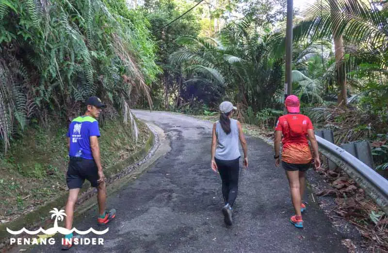
There are only two ways of getting to Maxwell Hill’s summit: taking a government-owned Land Rover, or braving the 10-kilometer hike to the summit. Driving your own car is not allowed because of the steep road that’s not in good conditions, and the fact there would be no space for many vehicles on the narrow roads at the top.
Walking is also a possibility: as we have done it ourselves, we will describe the hike to the summit of Bukit Larut in detail below.
Maxwell Hill’s Land Rover Service
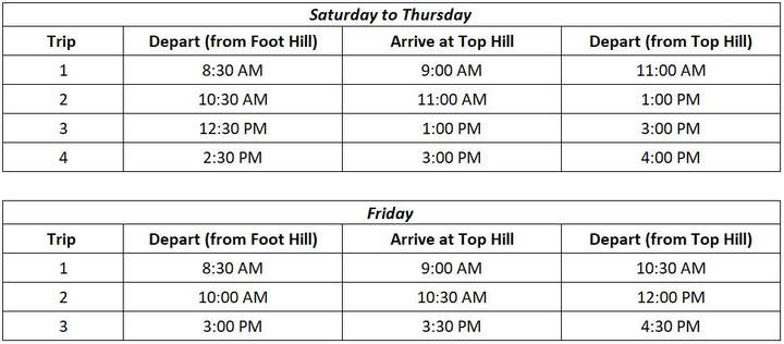
Until services were halted in April 2020 because of the coronavirus pandemic, the easiest way to reach the top of Bukit Larut was using the land rover service leaving from the Park Headquarters.
Government-owned Land Rovers used to charge RM 10 each way, driving the 10 kilometers to the summit in about half an hour. As this option is not available at the moment, we recommend calling the Bukit Larut Recreation Office at 05–8077241/7243 to inquire about the continuation of the service.
For your future reference, this was the timetable of Land-Rovers to the summit of Bukit Larut before the travel restrictions:
Hiking to the Summit of Bukit Larut
Hikers will rejoice, as Bukit Larut is still open even during Malaysia’s Recovery Movement Control Order, and Maxwell Hill can be accessed from 6.30 am to 7 pm.
Hiking Bukit Larut is a 13 km circuit that takes about 7 hours round trip and mostly follows the paved Land Rover road until the summit. Most local hikers don’t get all the way to the Stesen (Bukit Larut’s summit) but stop at one of the several Huts along the way, or at the Tea Garden, a popular mid-way stop.
This article will describe the different phases of Bukit Larut’s hike in detail so that you may choose what fits you and your schedule best.
Bukit Larut Land Rover Station to Hut 3
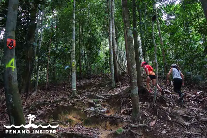
The first part of the Bukit Larut hike is possibly the most interesting as it goes through a jungle path — the only “wild” section along this trail that’s otherwise all along a paved road to the top.
Start at the Bukit Larut Park Headquarters, where you’ll have to register yourself — climbing up on foot is totally free of charge. Lookout on your left, straight opposite from the Land Rover parking station, and you’ll see a Bukit Larut stone fronting a landscape garden and a little wooden bridge behind it. That’s where you have to go to start following the path.
You’ll go through the jungle for about 30–45 minutes, depending on your level of fitness. The ascent is moderately steep and there are many tree roots in the way. Pay attention to the numbers marked on the bark of some trees, as these will help you keep on track. There are about 10 marked trees, after which you’ll reconnect to the main paved road where Hut 3, a small rest stop for hikers, awaits.
INSIDER TIP: Don’t miss the Hidden Waterfall
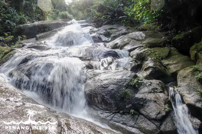
If you continue walking for 20 minutes from Hut 3 you’ll find a beautiful waterfall that’s a perfect picnic spot. Just stay on the left side, pass Hut 3’s bathrooms, and continue following a clearly marked trail that will swerve down and to the west. You’ll start hearing the falls here, so getting lost is out of the question. Allow an extra hour for a quick visit and plenty of time to take enough photos.
Hut 3 to Watermelon
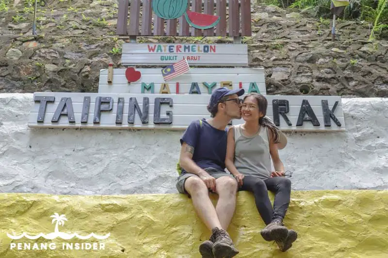
It’s roughly 2 kilometers uphill from Hut 3 to another rest area that the locals fondly call “Watermelon”. We asked some local hikers, and the reason seems to be because many enjoy to hike up to this point to eat watermelon together.
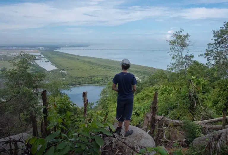
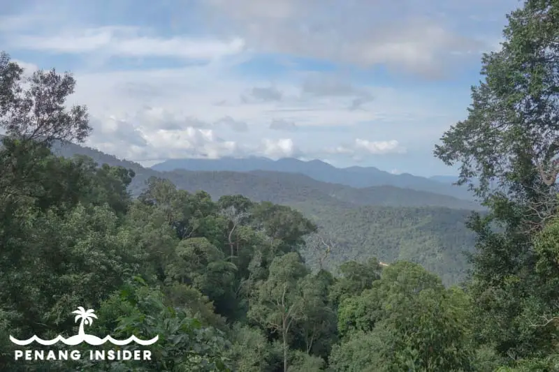
The views over Taiping start getting pretty nice from here — you’ll see the valley extend all the way to the mangrove-studded coast near Kuala Sepetang, 15 kilometers away from Taiping.
As far as Watermelon itself goes: the wall on the left is painted in yellow, white, and black (the colors of Perak’s flag), and makes for a popular photo opportunity spot.
Tea Garden: Bukit Larut’s Midway Point
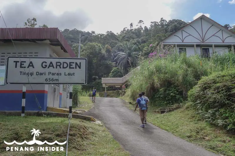
If you reach the Tea Garden, you’ll have walked 6 kilometers and you will be standing at 656 meters above sea level. This is the mid-point of the Maxwell Hill trek, and as far as most hikers go before turning back down. There isn’t much to see here besides a street sign and the former tea factory, which is now closed. Once upon a time, the tea gardens were scattered on the side of the hill, but you won’t see much left here today.
If you just walk for another few hundred meters you’ll find a beautiful, sloshing waterfall behind a fence on the right hand of the path. A very nice spot to take a rest.
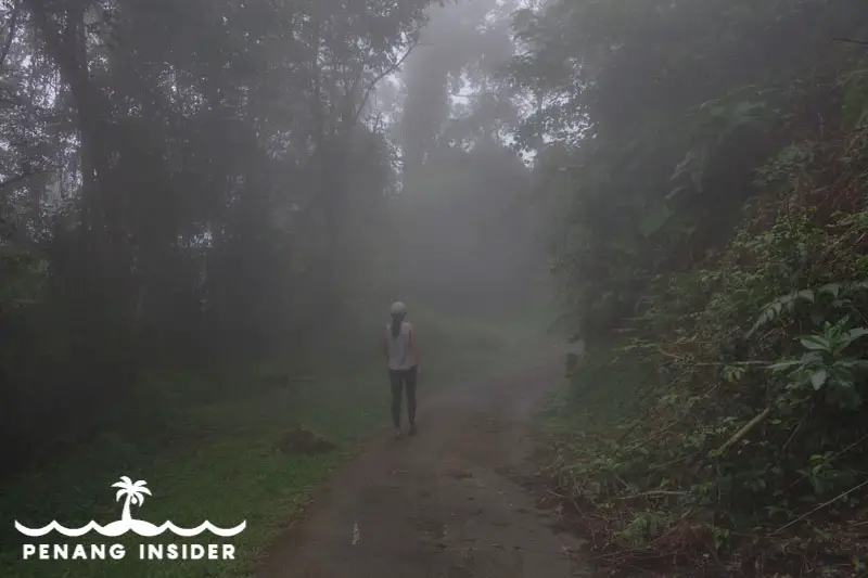
Bukit Larut Station
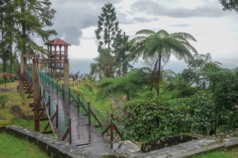
The next 3 kilometers keep winding upwards toward the top of Bukit Larut, called “Stesen” in Malay. This is where the Land Rover used to come to a halt, and also where Malaysia ends and colonial England starts: you’ll find mist, dark-green vegetation, flowers you won’t find in the tropical plains, and rows of cottages… which are unfortunately decaying to the point of rotting off their foundations! And I am sorry to say, this is quite a shame, for the place, if better maintained, would be a beautiful alternative to the overtouristed Cameron Highlands.
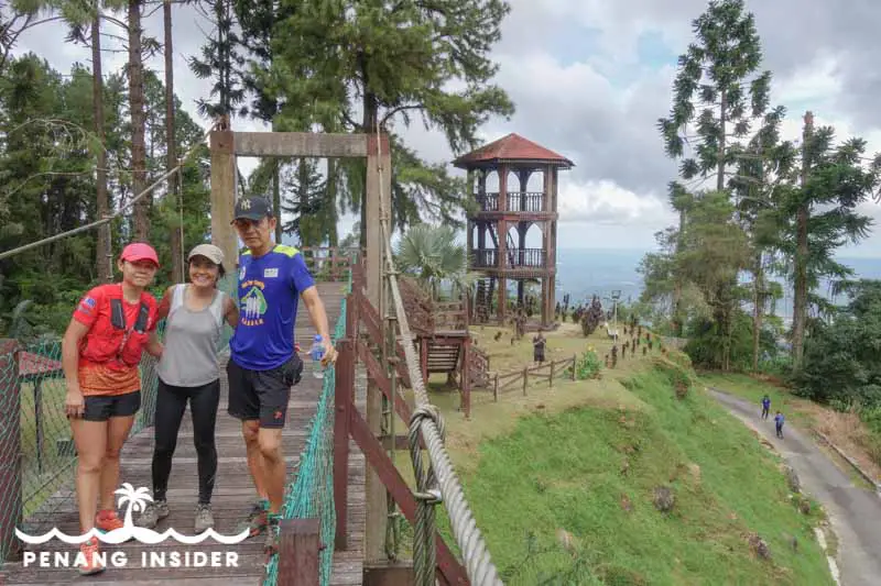
Anyways: if you manage to get all the way up here, you may pay a visit to the Sri Kaliaman Hindu Temple, possibly the highest Hindu shrine in Malaysia, and then walk over to the suspended wooden bridge and lookout post, an old and charming wooden tower. They both give a very old-world, colonial feel to the place.
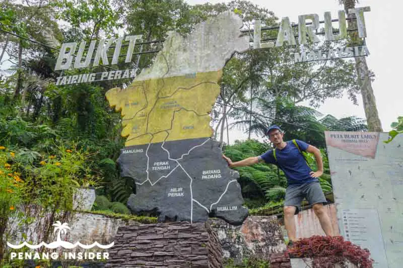
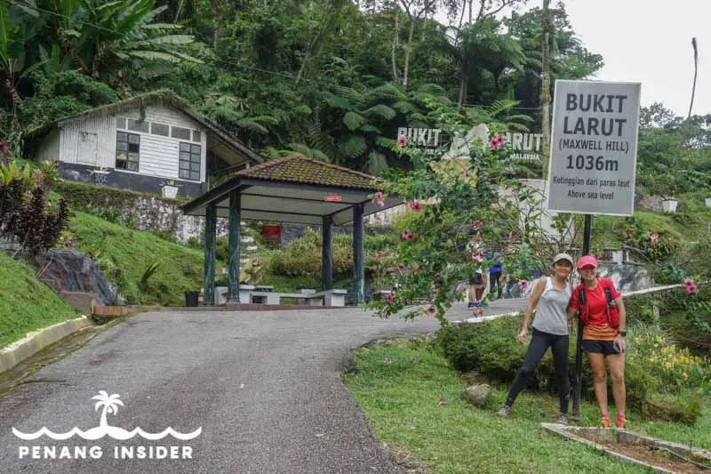
If you continue about a hundred meters up the road, you’ll get to the Bukit Larut sign and you’ll be standing at 1036 meters of height — not bad when considering that Penang Hill is only 830 meters high! Just behind it, a monument stone shaped as Perak state is one perfect spot to get one for the Gram.
Beyond Bukit Larut Station: the Telecom Tower
You are not finished yet: the trail actually continues beyond Maxwell Hill’s Station for another 4 kilometers. The first stretch is dotted with various bungalows, some of which still function as guesthouses — contact the Park Headquarters at the number mentioned above to ask about bookings. These places usually rent for the night, and hence best caters to big groups, as otherwise, the costs are prohibitive. Keep walking, and you’ll eventually reach a fork in the road that leads you to the Telecom Tower on the right, and to the peak of Gunung Hijau (1449-meters-high) on the left.
If you manage to attempt this climb in a day, you are definitely ultra-fit. We personally only arrived at the Station and spent a couple of hours enjoying the top and the bungalows in the direction of the Telecom Tower until a big storm rolled in and we felt like we had jumped from the tropics into a freezer, so we decided to come down.
We started at about 7.30 am and were back down by 4 pm.
Visiting Bukit Larut: the Verdict
We love Malaysian hills, and Bukit Larut is a top choice as it’s a pretty straightforward climb mostly along the paved road — not the best for adventurous hikers, but easier for those who don’t like to scramble along jungle terrain.
It is, however, a long hike that will take the best part of your day: make sure you have enough time if you intend to reach the summit, which means you must leave very early in the morning.
If you only want to have a feel for the hill or only a few hours to spare, we suggest you hike up to Hut 3 along the jungle path (1 hour up and 30 minutes down the paved road) or until the Tea Garden. This will be roughly a 4 to 5-hour roundtrip.
If you want to attempt the whole climb, make sure to book a Taiping hotel and stay in town the night before. Look at the beginning of this post for our preferred suggested hotels.