The Ultimate Guide to Gunung Tahan: Hiking Peninsular Malaysia’s Highest Peak
At 2187-meters in height, Gunung Tahan, or Mount Tahan, is the highest peak in Peninsular Malaysia and in the Tenasserim Hills chain (a 1,700-kilometre-long granite ridge older than the Himalayas) which runs all the way from mid-Thailand down to southern Peninsular Malaysia.
Only reachable after several days on foot through some of the country’s most pristine forests and ecosystems, Gunung Tahan is considered the most difficult climb in the region — go figure, in the Malay language, its name is translated as “mount endurance”.
Gunung Tahan is a real beauty and a fantastic destination for both hiking and nature enthusiasts: hidden in the northwestern corner of 4,343 km² protected Taman Negara Pahang, Gunung Tahan is one last refuge for Malayan tigers, wild elephants, sun bears, and other elusive wildlife.
READ MORE – The Wildlife of Penang Island
After years of putting it on the backburner of our endless to-do list of travels, we finally hiked Gunung Tahan in June 2022. It was one of the best experiences we had not only in Malaysia but in the whole world.
This post will tell you all you need to know to prepare for and successfully climb Gunung Tahan — a once-in-a-lifetime, must-do experience.
Also remember that Penang island, where we live, has many hiking trails, including treks on Penang Hill. The hiking routes extend well beyond the island: there are even more hiking trails in Penang Mainland at Seberang Perai.
Why Hiking Gunung Tahan is so incredible
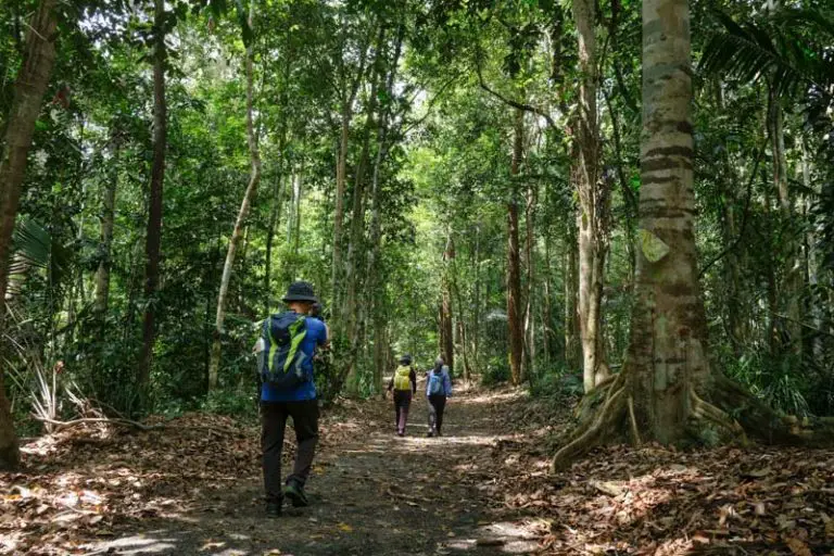
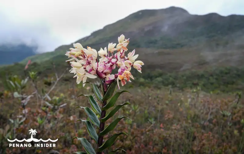
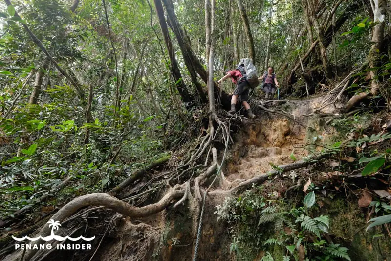
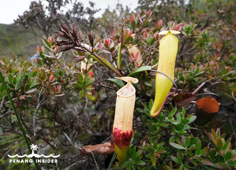
The forest of Taman Negara surrounding Gunung Tahan is one of the world’s oldest and Malaysia’s best preserved primary rainforests that’s millions of years old. I’ve been to over 70 countries around the world, and trust me, a rainforest as pristine as this one it’s hard to come by.
The other specialty of hiking Gunung Tahan is that you’ll travel from the lowlands up to the peak, passing all types of tropical ecosystems on the way — from rivers flanked by dipterocarp forest to mossy forest and highland grasslands, where trees are scarce and shrubs aplenty. Gunung Tahan really has it all.
How to get to Gunung Tahan
Gunung Tahan soars in the middle of the jungle on the border of Pahang and southern Kelantan and can be reached either via the town of Merapoh or on a longer trek from Kuala Tahan, the entrance to Taman Negara National Park.
This is a map of Gunung Tahan’s peak:
Hiking to Gunung Tahan from Merapoh
Duration: 5 Days and 4 Nights
Terrain Remarks: you start and end in a jeep, have a much shorter acclimatization time, and will have to hike the same, very steep trail to the peak up and down.
The shortest route to Gunung Tahan is from Merapoh — a great place in itself for amazing caving and other things to do, including the Sungai Relau Treetop Walk, — via the Sungai Relau entrance of Taman Negara, which is 7km inland from Merapoh’s main township.
From here, the jeep makes the 40-minute 4WD Journey to Kuala Juram — 100RM up to 4 people or 25RM/pax one way — from where the trail proper starts.
It’s the most popular route because it’s shorter (about 40km two ways) but it’s very steep. It’s also more monotone, as going up and descending is by the same path, with the same scenery.
How Can I Reach Gunung Tahan’s trailhead in Merapoh?
You can take a bus from Kuala Lumpur to Kuala Lipis and then arrive in the town by train. But the best way remains to use your own wheels, especially because there’s no public transport from Merapoh town to the Sungai Rulau National Park entrance.
You can park your car free of charge at the national park, where there is always somebody on duty to take care of it. This is perfect for those who start and end in Merapoh.
Here’s a map of the national park entrance, from where rangers will drive you to the trailhead at Kuala Juram:
Hiking to Gunung Tahan from Kuala Tahan
Duration: 7 Days and 6 Nights
Terrain Remarks: you walk all the way to Kuala Juram, where you end the trek with a jeep ride. More time means more time walking in the lowlands, which are beautiful, before climbing the mountain from a side that’s less steep than Merapoh.
The longest route to Gunung Tahan is from Kuala Tahan via the main entrance of Taman Negara National Park. The trail follows the route to Lata Berkoh and then swerves and proceeds inland towards the Melantai Camp.
This route is spectacular, but less popular because it’s longer at about 70km. All hikers care about, usually, is reaching the peak. But by not going via Kuala Tahan, they miss so much amazing and different scenery.
Consider, that this is a tough trail and completely self-sustained, and coming from Kuala Tahan one has to attempt 27 (small) hills and 12 river crossings in the first three days before starting to climb Mount Tahan proper.
How Can I Reach Gunung Tahan’s trailhead in Kuala Tahan?
You can take a bus to Jerantut from Kuala Lumpur or arrive in the town by train. From Jerantut to Kuala Tahan, at the moment only private shuttle minivans organized by Han Travel ply the route and cost RM25/person. Book your ticket at the NKS Travel office (a sister company of Han travel) along Jerantut’s main road in the old town.
If you drive your own car, the best is to park it free of charge at the Taman Negara Sungai Relau national park headquarters near Merapoh. This is easily done if you travel in a group and is what we did ourselves: leave one car at the arrival point in Merapoh, drive to Jerantut where you can park your car, and then take the transport to Kuala Tahan. At the end of the 7 days hike, drive the first car back to Jerantut and get the other car.
Here’s a map of Taman Negara Pahang headquarters, from where you’ll start your hike:
Can I hike Gunung Tahan by myself?
No, you need to hire a compulsory guide through the Taman Negara Park Office or private operators such as NKS Travel and Han Travel in Jerantut, or Merapoh Adventures in Merapoh. Consider that recently in 2022, people have injured themselves climbing and even died on the mountain. There’s no way around getting a guide, sorry.
How much does it cost to hike Gunung Tahan?
In 2022, the cost to hire one mountain guide for up to a maximum of 10 hikers is RM1820 for the whole trip. This excludes:
- camera fee RM5
- camping fee RM1 per person per night
You have to be completely self-sufficient by bringing your own food, camping gear, tent, and everything else you may need.
Many people prefer to have porters to help them carry their stuff, and each porter costs RM 1820 and will carry between 10 and 15kg for you, excluding water. Hiring a porter really depends on your needs and preferences — we honestly did not need to hire one.
Sleeping while trekking to Gunung Tahan
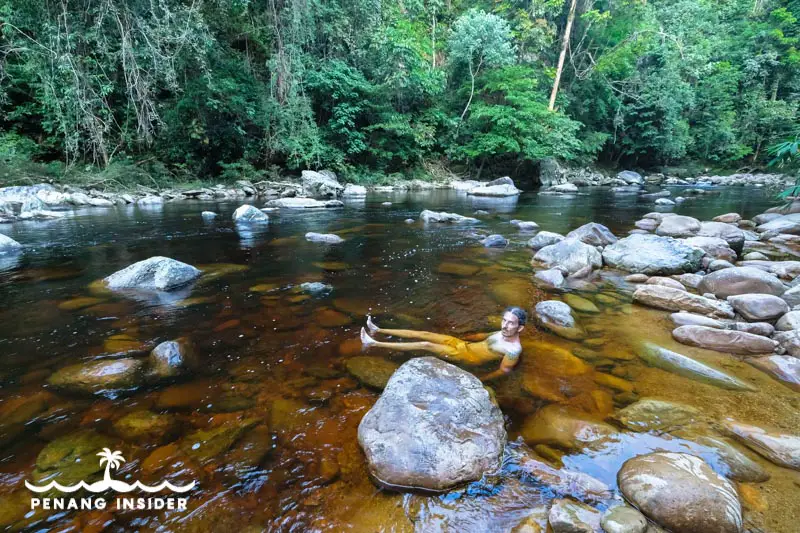
There are no sleeping facilities or rest houses anywhere along the Gunung Tahan trail and even most of the campsites are very basic. Water sources are no problem in the lower flanks, as you’ll most often sleep next to a river. But once you climb, water is often in very limited supply.
You need to bring everything you need, and in terms of sleeping, tents are preferred. Don’t think that just a hammock will do, because in some parts of the mountain there are limited trees, making it pretty much impossible to string your hammock.
Make sure your tent has a flysheet for a rain cover, and bring a tarpaulin or insulating sheet of another kind to protect the bottom of your tent and, eventually, make roofing to be able to cook in bad weather.
Remember: you must be completely self-sufficient and able to relieve yourself in the wild — don’t be a nasty scum and dig proper holes in the ground before squatting. Cover your faeces and toilet paper with soil and rock, and have the decency of relieving yourself at least 100mt away from water sources to avoid soil pollution. This is a pristine rainforest after all, but people DO COOK using water from the river, so please avoid giving them diseases.
Climbing and Hiking Gunung Tahan: Our experience from Kuala Tahan
The route from Kuala Tahan to the summit is the longest and most scenic and passes through the following steps and camps:
Kuala Tahan (80m) – Kuala Melantai (140m) – Kuala Putih (160m) – Kuala Teku (205m) – Kem Tengah (415m) – Gunung Rajah (595m) – Bukit Sarsi (845m) – Gunung Pondok Dua (Wray’s Camp, 1,095m) – Kem Pangkin (1,265m) – Gunung Tangga (1,510m) – Gunung Reskit (1,635m) – Gunung Tangga Lima Belas (1,750m) – Gunung Gedung (2,066m) – Padang (1,800m) – Tahan summit (2,187m).
From the summit down to Merapoh, the steps are:
Tahan summit (2,187m) – Kem Botak (1,935m) – Bonsai (1,675m) – Belumut (1,450m) – Kubang (1,375m) – Permatang (785m) – Kem Kor (685m) – Lata Luis (520m) – Kuala Luis (240m) – Kuala Juram (205m) where the trail proper begins – 4WD to Sungai Relau (290m)
This is where we picked up our car and drove off.
Hiking Gunung Tahan: 7-Day Itinerary from Kuala Tahan to Merapoh
The following is a report of our experience. Times are very indicative because distances depend on the strength of each group and different hikers may have different experiences. By all means, consider that besides the river crossings, the trail can get very muddy — and trust me, you will never understand the meaning of lumpur before coming here.
Day 0: Kuala Tahan
Reach Kuala Tahan and relax, enjoying the fine food and last creature comfort before setting off for your adventure.
Day 1: Kuala Tahan to Kem Melantai
It’s about 5 hours from Taman Negara headquarters to the Kem Melantai. This is the easiest part of the trek and a mild introduction to what is about to follow.
Day 2: Melantai to Puteh
This day involves crossing the 27 minor hills of Bukit Malang, and it’s pretty much a whole 8 hours spent going up and down along this massive hilly terrain. The Puteh campsite is very beautiful, set at the side of the river, wide and ideal to rest at night and wash yourself and your clothes.
Day 3: Puteh to Teku
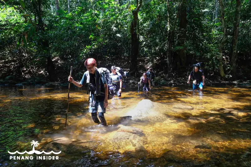
This is the day when things start getting tough and you have to pray to find good weather. There are 12 crossings on the Tahan river this day alone: wear a swimsuit and footwear that’s suitable to walk in the water and over slippery rocks in a river bed. If the water level is too high, the going gets very tough and your guide may advise stopping until the water gets lower. Don’t underestimate the strength of the river. Also, make sure to wrap all of your belongings inside two big plastic bags inside your backpack, as they may get wet. You need to maintain your food supplies and sleeping gear dry.
Day 4: Teku to Kem Pangking
The fourth day is a relentless uphill climb to 1,265-mt-high Kem Pangkin, which is kinda small and rocky in itself. Be prepared for a long, rough day, and squeeze a bit during the night. Large groups here are not recommended.
Day 5: Pangking to Padang via Gunung Tangga, Gunung Reskit and Gunung Tangga 15
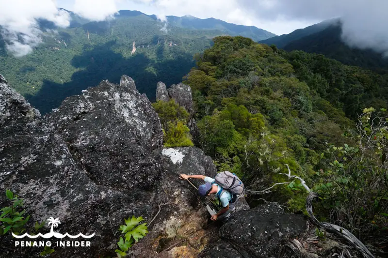
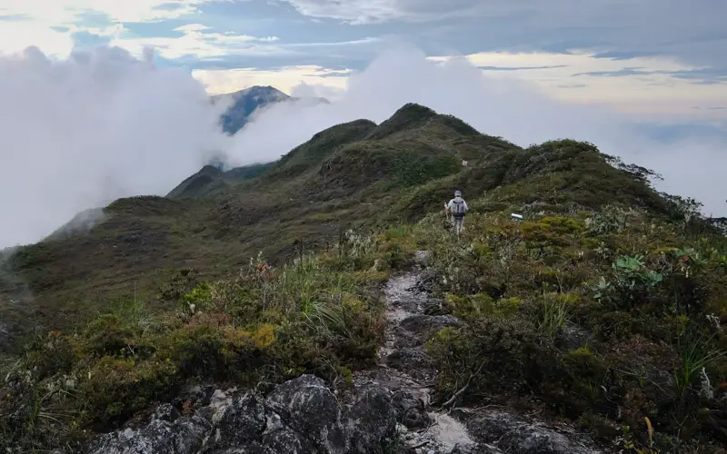
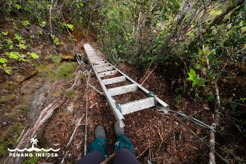
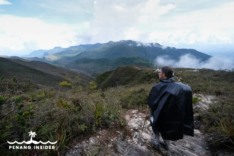
The fifth day continues the hardships of the fourth, including sections of climbing over rocks and up and down some rickety aluminium staircases that are only strapped with ropes to the rock face. The views from the upper range leading to Gunung Reskit, however, make it all worth it on a sunny day.
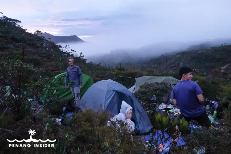
Many people stay the night at 2000 meters height at Camp Gedung, which certainly has beautiful views, but it’s very windy during the night. My group opted to proceed a bit further to Camp Padang, which is narrow and rocky but provides good shelter from the mountain winds.
Day 6: Padang Camp to Mount Tahan Summit and down to Belumut
This is a horribly muddy day. Mud is the staple diet on Gunung Tahan upper slopes, where the temperature is never too hot to dry the path in the mossy forest up there. Expect to get very dirty, and be slowed down to a crawl, especially if trying to keep yourself clean. After reaching the peak and down from Camp Botak, the last coming from the Merapoh side, the path becomes a pool of mud. And Belumut, where we stayed, it’s a very muddy camp — but no option, as we were too slow to make it to the much better Camp Kubang.
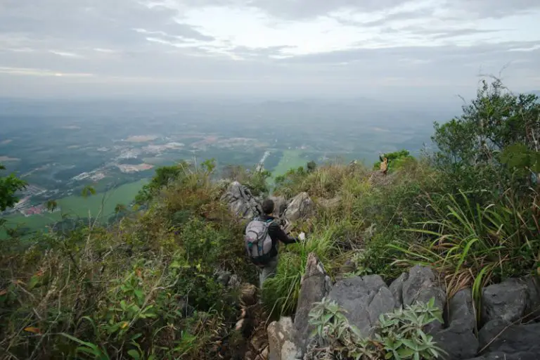
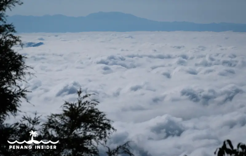
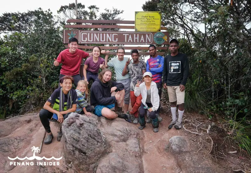
What about the peak of Gunung Tahan, right? We did not have nice views, unfortunately, but it was of course rewarding. The obvious photo opportunities will abound here. Just remember that the way down to Merapoh is another challenge ahead, and you better start tackling it as soon as you can.
Day 7: Belumut to Kuala Juram and Merapoh
After Camp Kubang, the mud finally stops and the trail returns solid, albeit very steep going down. A stick is essential to avoid injuring your knees. Once you reach Kem Kor at 685 meters you’ll meet the river again and finding water sources won’t be a problem anymore. Wash up, refresh, and be prepared for the final seven kilometers to Kuala Juram via the stunning Luis waterfall.
You will celebrate after crossing the last bridge into the settlement at Kuala Juram, which also has a Kelah Fish Sanctuary, and where you’ll find your jeep for the 40 minutes final ride (RM25/person) to the Taman Negara Park Headquarters at Sungai Relau, 7km away from Merapoh. Park your car there as advised or you’ll have trouble getting into town — the phone reception is not good over there, and you may end up spending another night camping at the national park.
Essential Gear for climbing Gunung Tahan
At a minimum, these are the essential items to climb Gunung Tahan:
- walking stick
- rubber shoes/sandals for river crossing
- waterproof tent
- inflatable mattress
- sleeping bag (it gets cold at night at higher altitudes)
- camping stove
- butane gas canisters
- camping cooking pot set
- cup and cutlery
- hiking pants
- swimsuit
- perspiring hiking shirt
- down jacket or long-sleeve fleece
- flip-flops to rest your feet at every break
- DEET mosquito spray that works very well against leeches
- headlight
- fast drying towel
Gunung Tahan’s Final Verdict
Gunung Tahan is one of the most incredible places I have ever seen and the most challenging hikes I have ever been on. Not only the millennial forest here is uncontaminated, you do have chances to spot wildlife — tigers are like needles in a tropical haystack, but it’s much more possible to bump into wild elephants and maybe sun bears. Expert guides will know what to do in case — most likely, stick to your own path and leave the animals alone.
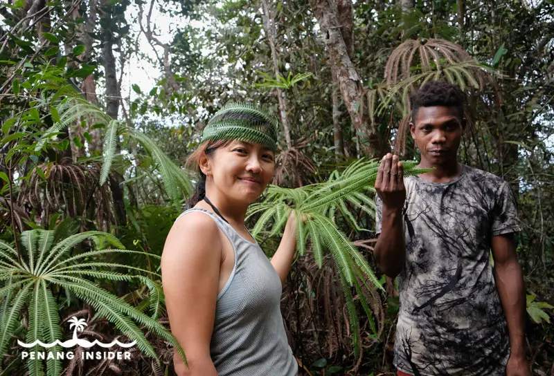
If you can, rather than hiring a Malay guide, go for an orang asli — the Batek people live in these forests — who will be better able to show you their unique relationship with the forest, most often foraging for edible plants to spice up your dinner.
Whatever way you look at it, climbing Gunung Tahan is a challenging, humbling experience that should not be attempted by beginner hikers. You’ll be completely deprived of any material comforts, including a proper bed and a hot shower, and you’ll have to cope with a complete self-supported immersion in nature. You only know if this adventure suits you or not, but if it seems it does, trust me, if you open yourself to this mighty mountain, you’ll return a changed person.
The research and writing for this article were jointly collaborated with Tourism Malaysia with a focus to boost tourism growth and promote Malaysia as a tourist destination post-COVID-19 pandemic.
Kindly visit the Tourism Malaysia Official page for more information.
YOU MAY ALSO LIKE
Best Hikes in Seberang Perai Penang
Hiking Gunung Pulai, Kedah’s toughest peak
Hiking Gunung Baling
Ultimate Guide to Kenong Rimba Park